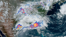
A brief period of cooler weather will be swiftly followed by more hot weather as June draws to a close, according to AccuWeather meteorologists.
On Friday and throughout the weekend, the Northeast and mid-Atlantic were engulfed in heat and humidity. For places like New York City, Saturday was the hottest day of the week, with the city's temperature reaching 90 degrees Fahrenheit for the first time since May 31. Due in large part to the urban heat island effect that is frequently observed in the area, the temperature in nearby Newark, New Jersey, soared to a scorching 96 F. Buffalo, New York reached 91 F on Saturday. Near the end of June, the city experiences average highs in the upper 70s.
Thunderstorms dotted the mid-Atlantic farther south and assisted in containing the heat. On Sunday, Richmond, Virginia, reached a high of 90 degrees, while Baltimore reached 91 degrees. Although these temperatures are only a few degrees above average for late June, the high humidity made it feel much hotter, with temperatures in the middle of the nineties.
Rain and thunderstorms will accompany the front that brought about the change, but refreshingly cool air will soon follow.
On Monday, there may be an increase in flight cancellations and delays due to storms and thunderstorms near important travel hubs.
From High to Low
Compared to the high temperatures over the weekend, Monday's and Tuesday's temperatures will be about 10 degrees cooler. On Monday, New York City will struggle to reach 80 degrees Fahrenheit; on Tuesday, it will remain in the lower 70s. Monday's high will be 85 degrees, and Tuesday's high will be 81, both below the typical late-June high of 89 degrees F.
Andrew Kienzle, an AccuWeather meteorologist, reports that on Monday, a cold front moving through the Northeast may bring storms and showers to the coast, but it will also bring cooler air from behind. As a result, the current period of hot weather will end right away.
Binghamton and Albany, New York, may have some of the region's coolest weather with highs through Tuesday averaging around 70.
People will have a window of opportunity to mow the lawn or perform other outdoor tasks without having to keep an eye on the radar for impending storms during this period of marginally cooler and less humid air.
Read also: Monsoonal Moisture Continues Across the Southwest US: Heavy Rain with Flash Flooding Expected
However, it is not expected that the return of cooler weather and lower humidity levels will last for very long. The cooldown's cause, a dip in the jet stream, will pivot offshore by Thursday, allowing heat and humidity to return just in time for the start of July.
By Friday, temperatures will once again reach the 90s in towns and cities along the Interstate-95 corridor, while they will reach the mid-to-upper 90s F in Virginia.
There won't just be hot weather in the regions east of the Appalachian Mountains. On Friday, temperatures are expected to be in the 90s in Syracuse, New York, Cleveland, and Pittsburgh as well.
By Independence Day, another trough in the jet stream is likely to bring cooler, more seasonable temperatures. This may end the heat but raises the possibility of inconvenient showers and thunderstorms, AccuWeather reports.
Related article: Hurricane Season: NHC Miami Issues Warning for Two Weather Disturbances over the Northern Gulf and Atlantic Ocean
© 2024 NatureWorldNews.com All rights reserved. Do not reproduce without permission.


